A watershed is an area of land where all of the rainwater that falls drains to the same place.
The Town Branch watershed covers 260 square miles in central and northwest Fayette County. The main tributaries to Town Branch are Wolf Run, which is a separate watershed contributing flow to the Town Branch watershed, and the Bracktown Branch and Bethel Road Tributary both of which are part of the Town Branch watershed.
As it leaves Fayette County, Town Branch flows into South Elkhorn Creek which eventually flows to the Kentucky River. Due to the underlying limestone and shale bedrock, the Town Branch watershed is located within a karst terrain. There are three known karst basins within the Town Branch Watershed: the Silver, Lindsay, and Mystery.
Although the Urban Service Area is highly developed, stormwater runoff is the most likely cause of pollution from E.coli and fecal coliform, nutrients and sediment from erosion and construction.
Watershed resources
Watershed monitoring in Town Branch
Watershed monitoring is an important tool to improve Lexington's water quality. Lexington recently finished a multi-year project to take water quality tests at different stream locations to help determine what pollutants to focus on to improve water quality. Each watershed has its own health report card.
| Parameter | Sources | Summary of monitoring results |
| E. coli | Sewage, animal waste, livestock manure | Poor |
| Total Suspended Solids | Upland or channel soil erosion; muddy water | Very good |
| Temperature | Runoff from excessively hot parking lots or roads; lack of shade typically provided by trees growing along creek banks | Very good |
| Dissolved Oxygen | Availability of oxygen for fish and other organisms to breathe | Fair |
| pH | The presence of too much acidity or too much alkalinity; neutral levels are needed for fish and other organisms | Very good |
| Conductivity | Dissolved solids, various salts, organic matter | Very poor |
| Chlorine | Water line break, swimming pool discharge | Very poor |
| Detergents | Sewage, graywater, outdoor washing of vehicles, floor mats, etc. | Very good |
| Ammonia-Nitrogen | Sewage, animal waste, livestock manure | Very good |
| Nitrate-Nitrogen | Excess fertilizer / manure runoff; too much can promote algae growth | Poor |
| Total Phosphorus | Excess fertilizer / manure runoff; too much can promote algae growth | Fair |
| Stream Habitat | Places where fish and other organisms can live | Poor |
| Aquatic Bugs / Critters | Conditions that support fish and other aquatic life | Poor |
Town Branch projects
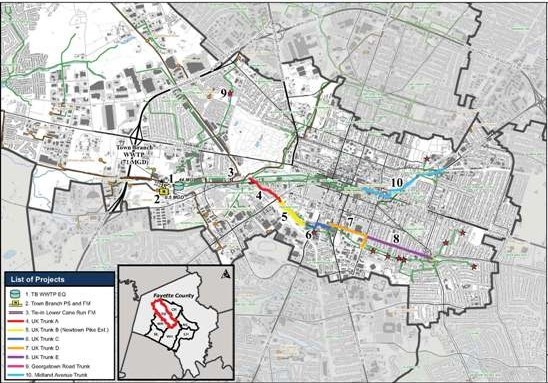
- Town Branch WWTP Equalization Tank
- Town Branch Pump Station & Force Main
- Lower Cane Run Force Main Tie-In
- UK Trunk Sewer Replacement A
- UK Trunk Sewer Replacement B (Newtown Pike Ext.)
- UK Trunk Sewer Replacement C
- UK Trunk Sewer Replacement D
- UK Trunk Sewer Replacement E
- Georgetown Road Trunk Sewer Replacement
- Midland Avenue Trunk Sewer Replacement