A watershed is an area of land where all of the rainwater that falls on it drains to the same place. Lexington has seven urban and two rural watersheds. South Elkhorn is located in the southwest part of Fayette County.
The South Elkhorn watershed drains to Fayette, Franklin, Scott, Woodford and Jessamine Counties. The main stem of South Elkhorn is approximately 52.7 miles long. It is composed of multiple subwatersheds - including Town Branch, Wolf Run, Shannon Run, Steele’s Run, and South Elkhorn Creek - of which portions are located in Fayette County.
The South Elkhorn “major watershed” area (as defined in LFUCG’s Phase 1 MS4 Permit) includes 37.8 mi2 of the South Elkhorn watershed within Fayette County that are not in the Town Branch or Wolf Run subwatersheds. South Elkhorn flows for approximately 18.1 miles from its headwaters to its confluence with Town Branch. Cave Creek, Manchester Branch, Shannon Run and Steele’s Run are the only other named tributaries in the South Elkhorn Watershed.
South Elkhorn is approximately 70% residential. Land use outside of the Urban Service Area but still within Fayette County was predominately agricultural/rural lands, followed by the Bluegrass Airport. South Elkhorn was listed on the 303(d) list as impaired for warm water aquatic habitat (partial support) and primary contact recreation (nonsupport) due to chlorine, fecal coliform, nutrient/eutrophication, organic enrichment (sewage), sedimentation/ siltation, and total dissolved solids. Suspected sources for the impairments for segments sunning through Fayette County include habitat modification, highway/road/bridge runoff, and loss of riparian habitat.
Watershed resources
Watershed monitoring in South Elkhorn
Watershed monitoring is an important tool to improve Lexington's water quality. Lexington recently finished a multi-year project to take water quality tests at different stream locations to help determine what pollutants to focus on to improve water quality. Each watershed has its own health report card.
The results for South Elkhorn include the parameter (the pollutant being measured); sources (where that pollutant comes from) and the monitoring results tell us the pollutants we need to work on most. In South Elkhorn, for example, we're doing a good job keeping soap and fertilizer out of our waterways, but we need to make sure we're also picking up pet waste on walks and in yards.
| E. Coli | Sewage, animal waste, livestock manure | Very poor |
| Total Suspended Solids | Upland or channel soil erosion; muddy water | Very good |
| Temperature | Runoff from excessively hot parking lots or roads; lack of shade typically provided by trees growing along creek banks |
Very good |
| Dissolved Oxygen | Availability of oxygen for fish and other organisms to breathe |
Very good |
| pH | The presence of too much acidity or too much alkalinity; neutral levels are needed for fish and other organisms |
Very good |
| Conductivity | Dissolved solids, various salts, organic matter | Poor |
| Chlorine | Water line break, swimming pool discharge |
Very good |
| Detergents |
Sewage, graywater, outdoor washing of vehicles, floor mats, etc. |
Very good |
|
Ammonia-Nitrogen |
Sewage, animal waste, livestock manure |
Very good |
| Nitrate-Nitrogen | Excess fertilizer / manure runoff; too much can promote algae growth | Poor |
| Total Phosphorus | Excess fertilizer / manure runoff; too much can promote algae growth | Good |
| Stream Habitat | Places where fish and other organisms can live | Poor |
| Aquatic Bugs / Critters | Conditions that support fish and other aquatic life | Fair |
Sanitary Sewer projects
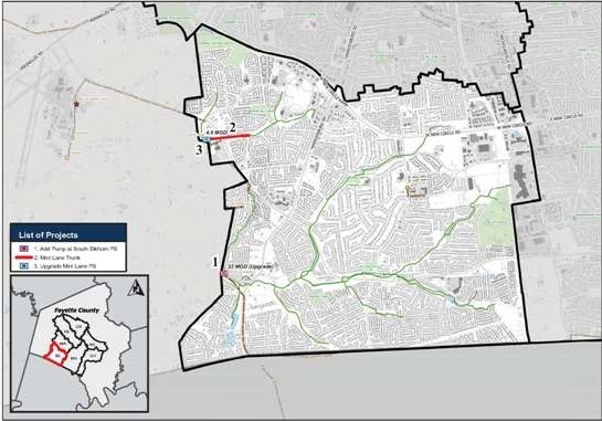
- Pump at South Elkhorn PS
- Mint Lane Trunk
- Mint Lane Pump Station Upgrades