A watershed is an area of land where all of the rainwater that falls drains to the same place.
The North Elkhorn watershed is 95 square mile located in northeast Fayette County and southern Scott County. North Elkhorn Creek flows for almost 25 miles from its headwaters in Fayette County until it meets up with South Elkhorn Creek, just east of Frankfort. Creeks that flow into North Elkhorn include David Fork, Avon Fork, Bryan Station Creek, and Goose Creek.
Its watershed area is mostly rural within Fayette County, with urban land uses in the headwaters in the southeast. Together, agricultural, rural and some residential areas account for most land use within the watershed. Possible sources of pollution from stormwater runoff include dissolved solids, conductivity, E.coli and fecal coliform that may affect the health of North Elkhorn Creek and its tributaries.
Watershed resources
- Watershed Assessment
- Watershed Health Report Card coming soon!
Watershed monitoring in North Elkhorn
Watershed monitoring is an important tool to improve Lexington's water quality. Lexington recently finished a multi-year project to take water quality tests at different stream locations to help determine what pollutants to focus on to improve water quality. Each watershed has its own health report card.
| Parameter | Sources | Summary of monitoring results |
| E. coli | Sewage, animal waste, livestock manure | Poor |
| Total Suspended Solids | Upland or channel soil erosion; muddy water | Very good |
| Temperature | Runoff from excessively hot parking lots or roads; lack of shade typically provided by trees growing along creek banks | Very good |
| Dissolved Oxygen | Availability of oxygen for fish and other organisms to breathe | Good |
| pH | The presence of too much acidity or too much alkalinity; neutral levels are needed for fish and other organisms | Very good |
| Conductivity | Dissolved solids, various salts, organic matter | Very poor |
| Chlorine | Water line break, swimming pool discharge | Poor |
| Detergents | Sewage, graywater, outdoor washing of vehicles, floor mats, etc. | Very good |
| Ammonia-Nitrogen | Sewage, animal waste, livestock manure | Good |
| Nitrate-Nitrogen | Excess fertilizer / manure runoff; too much can promote algae growth | Very good |
| Total Phosphorus | Excess fertilizer / manure runoff; too much can promote algae growth | Very good |
| Stream Habitat | Places where fish and other organisms can live | Poor |
| Aquatic Bugs / Critters | Conditions that support fish and other aquatic life | Poor |
Projects in North Elkhorn
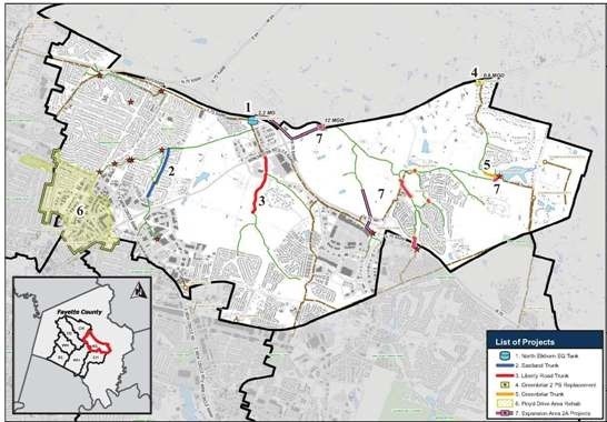
- North Elkhorn Equalization Tank
- Eastland Trunk Sewer Replacement
- Liberty Road Trunk Sewer Replacement
- Greenbriar 2 Pump Station Replacement
- Greenbriar Trunk Sewer Replacement
- Floyd Drive Area Rehabilitation
- Expansion Area 2A Projects
North Elkhorn stormwater projects