A watershed is an area of land where all of the rainwater that falls on it drains to the same place. Lexington has seven urban and two rural watersheds.
The Cane Run watershed is a 45.4 square mile (mi2) watershed located within Fayette and Scott Counties, Kentucky. The 45 square mile watershed begins in central Fayette County and flows north into Scott County where it meets up with North Elkhorn Creek. The watershed has many karst features such as sinkholes, springs and caves.
The Royal Spring karst basin serves as the water supply for Georgetown. The majority of Cane Run's land is residential, followed by office, industry and research parks. The most significant water quality pollutant in Cane Run is E. coli and fecal coliform, a focus of restoration efforts in the watershed.
Watershed resources
Watershed monitoring in Cane Run
Watershed monitoring is an important tool to improve Lexington's water quality. Lexington recently completed a multi-year project to perform water quality testing at different stream locations in each watershed to help determine what pollutants to focus on to improve water quality. The results for Cane Run include the parameter (the pollutant being measured); sources (where that pollutant comes from) and the monitoring results tell us the pollutants we need to work on most. In Cane Run, for example, we're doing a good job keeping soap and detergents out of our waterways, but we need to make sure we're also picking up pet waste on walks and in yards.
| Parameter | Sources | Summary of monitoring results |
| E. coli | Sewage, animal waste, livestock manure | Very Poor |
| Total Suspended Solids | Upland or channel soil erosion; muddy water | Very Good |
| Temperature | Runoff from excessively hot parking lots or roads; lack of shade typically provided by trees growing along creek banks | Very Good |
| Dissolved Oxygen | Availability of oxygen for fish and other organisms to breathe | Very Good |
| pH | The presence of too much acidity or too much alkalinity; neutral levels are needed for fish and other organisms | Very Good |
| Conductivity | Dissolved solids, various salts, organic matter | Very Poor |
| Chlorine | Water line break, swimming pool discharge | Very Good |
| Detergents | Sewage, graywater, outdoor washing of vehicles, floor mats, etc. | Good |
| Ammonia-Nitrogen | Sewage, animal waste, livestock manure | Very Good |
| Nitrate-Nitrogen | Excess fertilizer / manure runoff; too much can promote algae growth | Very Poor |
| Total Phosphorus | Excess fertilizer / manure runoff; too much can promote algae growth | Very Good |
| Stream Habitat | Places where fish and other organisms can live | Poor |
| Aquatic Bugs / Critters | Conditions that support fish and other aquatic life | Poor |
Projects in Cane Run
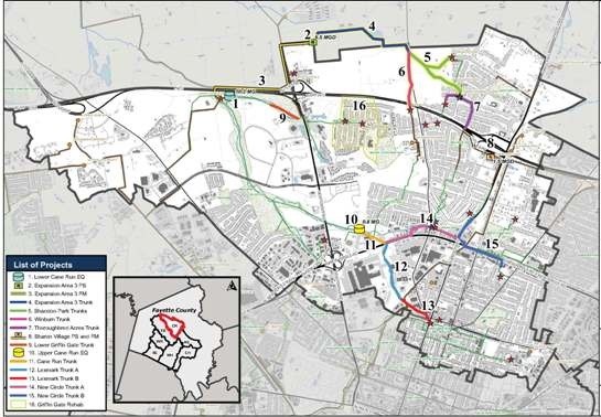
Download a printable PDF of the map
- Lower Cane Run Equalization Tank
- Expansion Area 3 Pump Station
- Expansion Area 3 Force Main
- Expansion Area 3 Trunk
- Shandon Park Trunks
- Winburn Trunk
- Thoroughbred Acres Trunk Sewer Replacement
- Sharon Village Pump Station and Force Main
- Lower Griffin Gate Trunk Sewer Replacement
- Upper Cane Run Equalization Tank
- Cane Run Trunk Sewer Replacement
- Lexmark Trunk Sewer Replacement A
- Lexmark Trunk Sewer Replacement B
- New Circle Trunk Sewer Replacement A
- New Circle Trunk Sewer Replacement B
- Griffin Gate Area Rehabilitation
More information on these projects.
Cane Run stormwater projects